|
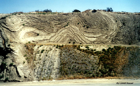
Folding and faulting associated with the San Andreas fault, along highway 14 near Palmdale, California.
|
|
|
Folding and faulting
associated with the San Andreas fault, along highway 14 near Palmdale,
California.
|
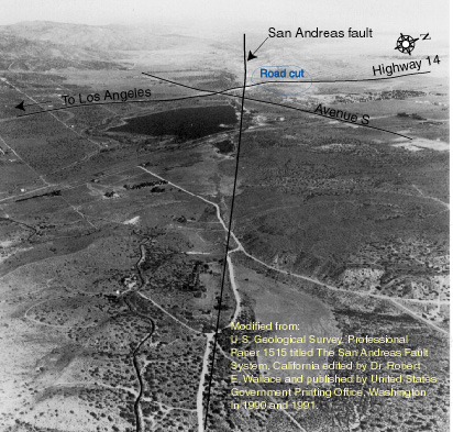
Abstract by Lowell Kessell The purpose of this study was to determine
the mechanics related to folding and faulting exposed in the Hwy 14 road
cut near Palmdale. The roadcut is 27 m high and 600 m long and oriented
nearly perpendicular to the San Andreas fault (exposed at the southern
end of the cut) and the Little Rock fault (located about 76 m north of
the north end of the cut) and can be considered to be a large ìtrenchî.
The Little Rock fault is a right slip fault with about 20 km estimated
offset. The road cut exposes complexly
folded and faulted, lower to middle Pliocene,
gypsiferous, lacustrine rocks of the Anaverde Formation. They are unconformably
overlain by undeformed Pleistocene gravel, suggesting that folding and
faulting occurred prior to their deposition.
|
|
|
|
View northwestward along the San Andreas fault with the Mojave Desert to the right and the San Gabriel Mountains to the left. Use topographic map for reference and location. |
|
1952 Aerial photograph of the area prior to construction of highway 14 and excavation of the road cut. Fold and fault map of the area centered on the road cut. The map has traces of fault segments, folds, and the location of the San Andreas fault and the Little Rock fault. A photo-mosaic of the road cut may be posted here someday and will illustrate all the structures within the road cut. |